Maps
ARDI can be configured to include maps of your plants (and even of sub-areas, such as individual areas, sections or even control panels).
Accessing
You can access maps several ways….
- By clicking on the button in the Maps section of the find assets page.
- By accessing the asset dashboard on an asset that already has a position and choosing the 'Location: Map' button.
- By clicking on the Map icon on the right of a scan in ARDI-AR.
Controlling
Controlling your view of the map should be quite familiar to most people. On a desktop PC, you click-and-drag to pan (ie. move) the map around, and the mouse-wheel to zoom in and out.
On touch-devices such as mobile phones and tablets, you touch-and-drag to move, and pinch-zoom (hold two fingers on the screen and either spread them apart or bring them closer together) to zoom.
One item on the map can be selected, indicated by a spinning green circle as shown below.
You can select assets by clicking on them - they appear as coloured dots or squares around the map.
Toolbox
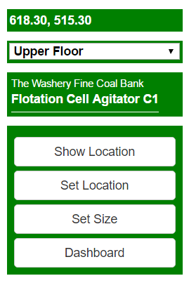
The top-right of the map screen contains the toolbox.
If you have multiple levels to your map, the drop-list (pictured to the right showing 'Upper Floor' ) can be used to switch between them.
If an asset is selected, you can highlight its location, change it's location or size, or view the assets dashboard using the buttons located here.


